

At least one person has died and five others have been injured after a 5.6-magnitude earthquake struck off the coast of Peru, sending tremors through the capital, Lima.
According to the United States Geological Survey (USGS), the quake occurred at 11:35am local time (16:35 GMT) on Sunday in the Pacific Ocean. The epicentre was recorded 23km (14 miles) southwest of Callao, a key port city adjacent to Lima. However, the Peruvian presidency reported a stronger reading of 6.1 in magnitude. Authorities confirmed the quake did not trigger a tsunami warning.
In a message posted on X (formerly Twitter), the Peruvian presidency announced that President Dina Boluarte was en route to Callao to assess coastal conditions following the seismic event.
Police Colonel Ramiro Clauco told the RPP radio network that a 36-year-old man was killed in northern Lima while he was “standing outside his vehicle waiting for a passenger.”
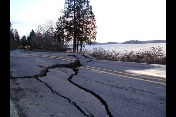
Peru’s Emergency Operations Centre reported that five people were receiving medical care in local hospitals. The earthquake also caused structural damage to roads and educational facilities. Hernando Tavera, head of the Geophysical Institute of Peru, said on television that the tremor was felt across all districts in Lima.
Local media outlets also reported the cancellation of a major football match scheduled to be played in Lima as a direct result of the earthquake.
Peru is located along the Pacific Ring of Fire, a geologically active zone known for frequent earthquakes and volcanic activity. The country experiences an average of 100 detectable earthquakes annually.
The last significant earthquake in Peru took place in 2021 in the Amazon region. It registered a magnitude of 7.5, injured 12 people, and destroyed more than 70 homes. The deadliest earthquake in the nation’s history struck in 1970 in the Ancash region, unleashing massive landslides that claimed approximately 70,000 lives.